VESPA EN QUELQUES MOTS /
Les travaux de la Chaire prennent forme dans le laboratoire Ville et ESPAces politiques (VESPA), mis en place au cours de l’année 2006.
Le VESPA est un espace multimédia équipé des appareils nécessaires à la
cueillette de données visuelles et audiovisuelles (photo, vidéo, trames
sonores), à leur traitement (poste ordinateur et logiciels de montage
vidéo, photo ; logiciel de retranscription d’entretiens, logiciels de
codification, etc.) à leur archivage, au travail en réseau (serveur) et à
leur diffusion.
Mille mots pour une image / Reportage par Paul Lervy-Meyere
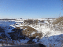

Saint-Michel n’est pas qu’un « quartier difficile » ! : la mobilisation populaire dans la revitalisation territoriale
À la fois espace physique, politique, économique et social, le quartier est un micro-système vivant qui interagit avec d’autres systèmes plus grands : la ville, la région, la nation, le monde (Authier et al. 2006 ; Keans et Parkinson 2001). Produit et producteur de dynamiques, une quantité infinie de qualificatifs peut lui être appliquée. Les activités qui s’y déroulent peuvent contribuer à sa caractérisation, comme le quartier des affaires qui concentre les entreprises mondialisées et hyper-connectées, ou le quartier des spectacles accueillant salles de concert et lieux de productions artistiques. Il peut également être défini par sa population en termes ethniques comme le quartier Chinois, ou culturels dont les quartiers gais. Il peut être interprété en fonction du niveau de vie : le quartier riche ou le quartier pauvre par exemple. Un autre moyen de qualifier le quartier peut aussi être en termes dynamiques, il pourra ainsi être le quartier innovant, créatif, de rénovation, ou celui de l’exclusion, ou de la relégation. Mais bien que décrivant une réalité, ces adjectifs figent le quartier dans une posture et une identité. Ils le réifient. Ceci est d’autant plus vrai que l’on parlera des quartiers stigmatisés qui cumulent les difficultés. Ils sont essentiellement lus avec les théories des effets de quartier qui postulent la création et l’entretien d’un cercle vicieux impactant tant la population que le quartier dans son ensemble. Mais les quartiers dits stigmatisés le restent-ils à jamais, est-ce une fatalité ?
Voir reportage »Nouvelles parutions /
02.2017 | By Julie-Anne Boudreau | Wiley Publication| Jan 2017
Global Urban Politics : Informalization of the State
07.2015 | Un chapitre de Julie-Anne Boudreau dans Translating the city
Urbanity as a way of life...?
07.2015 | Mouvement étudiant du printemps 2012 au Québec : exploration du répertoire d’action mobilisé
Nouvel article par Mathieu Labrie juin 2015
07.2013 | Parution chez Taylor and Francis
Article co-écrit par Mathieu Labrie
Mathieu Labrie, membre doctorant du VESPA, co-écrit : Capital, méga-événement et droit à la ville :
une triple dialectique vue à travers les expériences Olympiques de
Montréal et Rio de Janeiro.
03.2013 | Publications en ligne [WWW]
Nathalie Boucher co-écrit : " 100, Somerville"
Nathalie Boucher, ex-membre du VESPA, co-écrit un article : "100, Somerville". La piste cyclable du nord de l’île de Montréal suit infidèlement le
boulevard Gouin, avec quelques chicanes sur les rues adjacentes. Sur une
de ces rues, Somerville...
06.2012 | Volume dans Emotion, Space and Society
Dirigée par Julie-Anne Boudreau, " Urbanity, fear, and political action : Explorations of intersections"

2009 | Projets de recherche
Appréhensions et opportunités face à la mobilité des jeunes. Le cas montréalais
Suite à une série d’articles médiatisés sur les gangs de rue à Montréal
et leurs déplacements vers Laval, l’objectif est de mieux comprendre ...

Réflexions épistémologiques
Présentation du Laboratoire VESPA. Pour une épistémologie de l’urbanité
Considérant l’intensité actuelle et mondiale de l’urbanisation
accélérée, le VESPA s’interroge à propos de son impact sur la production
des connaissances et sur les processus politiques.

Suggestions d’activités à Montréal
nos coups de coeur
L’année 2015 est bouillante d’activités à Montréal et les membres du VESPA découvrent et partagent des activités locales...voici nos coups de coeur ou suggestions du moment>>


Hanoi septembre 2013
Nouvelles de terrain- Des espaces publics accueillants pour les jeunes
Notre équipe travaille sur plusieurs terrains à Hanoi, Montréal et en banlieues de Paris en 2013 et 2014 : nous partageons ici des photos de nos chercheurs, intervenants et jeunes, croqués sur le vif.
LÉGENDE DE PHOTO :
Le caméscope, un outil amical. Le personnel de ménage de Vinaconex, Hanoi. Photo par Alice Miquet, 2013